Hydrographic Services
Typical applications
- Mapping of harbours, inland waterways and shipping channels with critical keel clearance
- Inspection of underwater infrastructure
- Detection and mapping of debris and other under-water objects
- Detailed surveys related to underwater construction work or dredging
- Environmental seabed and habitat mapping
- Mapping of biomass in the water column

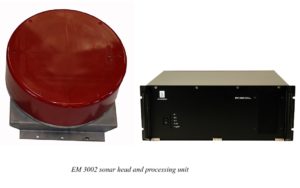
The EM 3002
is an advanced multibeam echo sounder with extremely high resolution and dynamically
focused beams. It is very well suited for detailed seafloor mapping and inspection with water depths
from less than 1 meter up to typically 200 meters in cold oceanic conditions. Maximum depth capability
is strongly dependant on water temperature and salinity – up to 300 meters is possible under favorable
conditions.
Typical applications
- Mapping of harbours, inland waterways and shipping channels with critical keel clearance
- Inspection of underwater infrastructure
- Detection and mapping of debris and other under-water objects
- Detailed surveys related to underwater construction work or dredging
- Environmental seabed and habitat mapping
- Mapping of biomass in the water column